


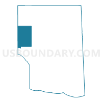
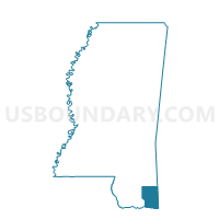
Latimer Voting District, Jackson County, Mississippi
About
Outline

Summary
| Unique Area Identifier | 605743 |
| Name | Latimer Voting District |
| County | Jackson County |
| State | Mississippi |
| Area (square miles) | 55.14 |
| Land Area (square miles) | 55.13 |
| Water Area (square miles) | 0.00 |
| % of Land Area | 99.99 |
| % of Water Area | 0.01 |
| Latitude of the Internal Point | 30.54013570 |
| Longtitude of the Internal Point | -88.83354750 |
Maps

Graphs
Select a template below for downloading or customizing gragh for Latimer Voting District, Jackson County, Mississippi


Neighbors
Neighoring Voting District (by Name) Neighboring Voting District on the Map
- Voting District 111, Harrison County, MS
- Voting District 112, Harrison County, MS
- Gulf Hills Voting District, Jackson County, MS
- Gulf Hills B Voting District, Jackson County, MS
- Hwy 57 A Voting District, Jackson County, MS
- Larue Voting District, Jackson County, MS
- South Vancleave Voting District, Jackson County, MS
- St. Martin Voting District, Jackson County, MS
Top 10 Neighboring County Subdivision (by Population) Neighboring County Subdivision on the Map
- District 5, Jackson County, MS (33,532)
- District 1, Harrison County, MS (31,234)
- District 4, Jackson County, MS (30,708)
Top 10 Neighboring Place (by Population) Neighboring Place on the Map
Top 10 Neighboring Unified School District (by Population) Neighboring Unified School District on the Map
Top 10 Neighboring State Legislative District Lower Chamber (by Population) Neighboring State Legislative District Lower Chamber on the Map
- State House District 116, MS (29,749)
- State House District 114, MS (29,403)
- State House District 112, MS (27,137)
- State House District 113, MS (25,381)
Top 10 Neighboring State Legislative District Upper Chamber (by Population) Neighboring State Legislative District Upper Chamber on the Map
- State Senate District 51, MS (62,901)
- State Senate District 47, MS (58,112)
- State Senate District 52, MS (56,601)
- State Senate District 50, MS (51,017)
Top 10 Neighboring 111th Congressional District (by Population) Neighboring 111th Congressional District on the Map
Top 10 Neighboring Census Tract (by Population) Neighboring Census Tract on the Map
- Census Tract 34.02, Harrison County, MS (10,156)
- Census Tract 402.01, Jackson County, MS (8,613)
- Census Tract 33.01, Harrison County, MS (8,418)
- Census Tract 402.04, Jackson County, MS (6,602)
- Census Tract 34.04, Harrison County, MS (5,402)
- Census Tract 402.03, Jackson County, MS (5,102)